

Areas of the Midwest and Southeast that were recently slammed by a deadly barrage of powerful storms and flooding will face a renewed risk of severe weather on Thursday. FOX Weather Meteorologist Britta Merwin breaks down the latest forecast on Thursday, April 10, 2025.
Regions of the Midwest and Southeast recently slammed by a deadly barrage of powerful storms and flooding are continuing recovery efforts in the wake of the disaster, but now as residents try to sift through the rubble, they’re facing a renewed risk of severe weather on Thursday.
-

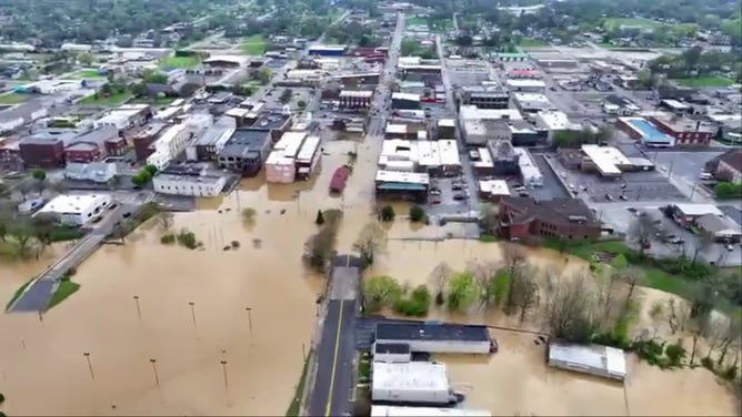
Aerial footage of the significant flooding situation in Louisville, Kentucky.
(Louisville Metro Police Department) -
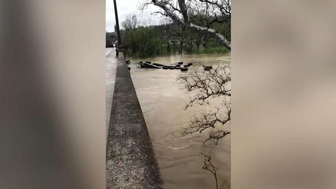
Pieces of a dock float down the Kentucky river after it crashed into the War Mothers Memorial Bridge in Frankfort.
( Michael R Fitzpatrick via Storyful) -

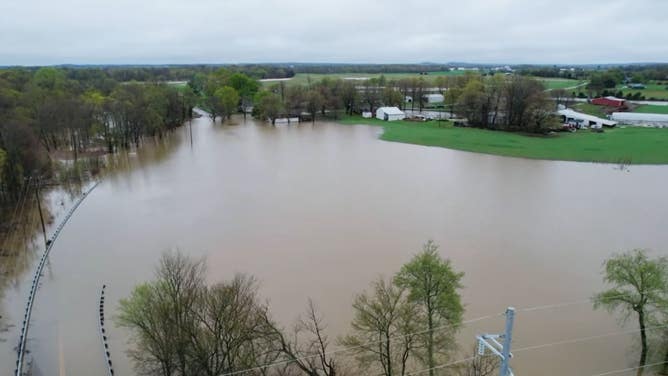
Water floods fields, roads and structures near the Bluegrass Parkway in Nelson County, Kentucky, on Monday, April 7, 2025.
(Ryan C. Hermens/Lexington Herald-Leader/Tribune News Service) -

Photo taken on April 7, 2025, shows a waterlogged area in Frankfort, Kentucky.
(Wang Changzheng/Xinhua via Getty Images) -

John Clayton, 56, carries his cat in a kayak as the Kentucky River begins to flood his house on April 6, 2025 in Frankfort, Kentucky.
(Michael Swensen/Getty Images) -
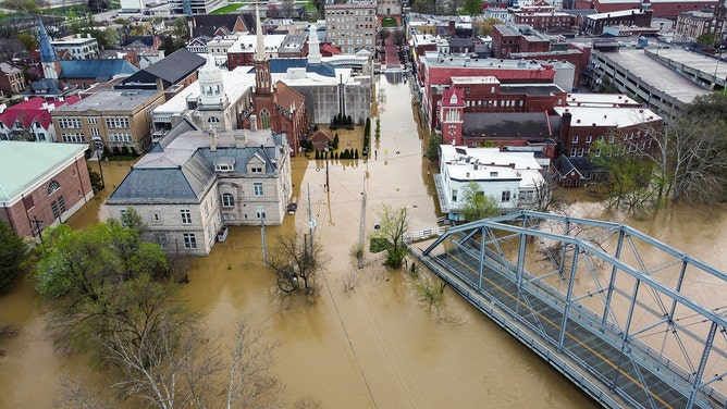
An aerial view of severe flooding in Frankfort, Kentucky, caused by days of heavy rainfall across the Midwest on April 7, 2025.
(LEANDRO LOZADA/AFP via Getty Images) -

An aerial view of severe flooding in Frankfort, Kentucky, caused by days of heavy rainfall across the Midwest on April 7, 2025.
(LEANDRO LOZADA/AFP via Getty Images) -

Scenes of the flood caused by heave rains across the Midwest of the US in Frankfort, Kentucky on April 7, 2025.
(LEANDRO LOZADA/AFP via Getty Images) -

Thomas Fenwick, 42, and Jo Rodriguez, 33, embrace as their neighborhood floods on April 6, 2025 in Frankfort, Kentucky.
(Michael Swensen/Getty Images) -

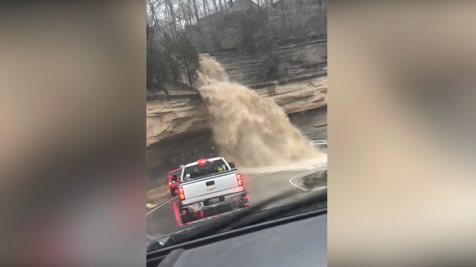
Drone photo shows a flooded Western Kentuck Parkway at the White Mills-Eastview Exit.
(Hardin County Sheriff’s Office/Facebook) -

Flooded highway 1375 in Glendale, Kentucky on Sunday.
(Hardin County Sheriff’s Office) -

Photo shows a flooded Highway 84 between WK & Four Corners.
(Hardin County Sheriff’s Office/Facebook) -

A car drives past the flooded Nolin River on a highway unaffected by flooding.
(Hardin County Sheriff’s Office/Facebook) -
Farm sits on the edge of flooding in Glendale, Kentucky.
(Hardin County Sheriff’s Office/Facebook) -

Scenes of the flood caused by heavy rains across the Midwest of the U.S. in Frankfort, Kentuky, on April 7, 2025.
(LEANDRO LOZADA/AFP) -

Aerial view of Buffalo Trace Distillery surrounded by floodwaters in Frankfort, Kentuky, after days of heavy rainfall across the Midwest on April 7, 2025. ing. (Photo by LEANDRO LOZADA/AFP via Getty Images)
( ) -

Aerial view of Buffalo Trace Distillery surrounded by floodwaters in Frankfort, Kentuky, after days of heavy rainfall across the Midwest on April 7, 2025. Violent storms battering the central-eastern United States have killed at least 17 people, officials said on April 5, 2025, with the National Weather Service warning of “devastating” flash flooding. (Photo by LEANDRO LOZADA / AFP) (Photo by LEANDRO LOZADA/AFP via Getty Images)
( ) -

Flooding in Cincinnati, Ohio on April 5, 2025 due to Ohio River flooding.
(Eric Willoughby/X) -

An aerial view of severe flooding in Frankfort, Kentucky, caused by days of heavy rainfall across the Midwest on April 7, 2025.
(LEANDRO LOZADA/AFP via Getty Images) -

An aerial view of severe flooding in Frankfort, Kentucky, caused by days of heavy rainfall across the Midwest on April 7, 2025.
(LEANDRO LOZADA/AFP via Getty Images) -
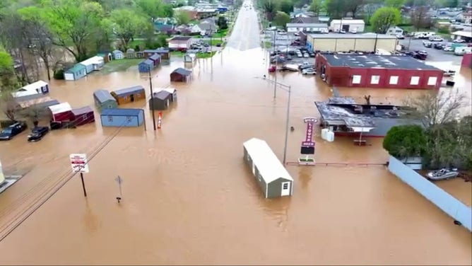
Flooding in Hopkinsville, Kentucky.
(Kirkman Aerial Photography / Facebook) -
Flooding in Hopkinsville, Kentucky.
(Kirkman Aerial Photography / Facebook) -
Hanging Rock Hill in Madison, Indiana.
(The Attic Coffee Mill Cafe) -

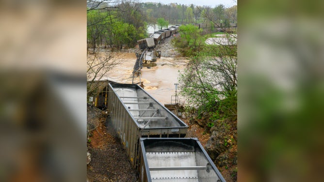
A trail derailed as the Warm Fork Spring River flooded during severe storms on April 5, 2025.
(Donell Russell) -
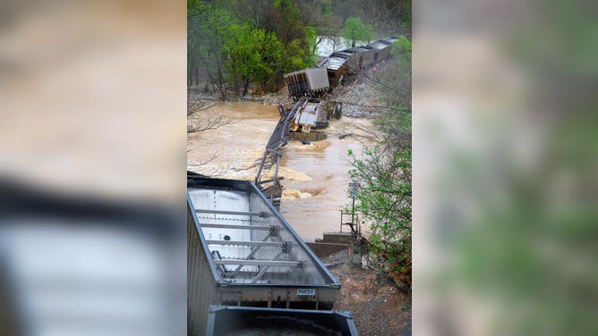
A trail derailed as the Warm Fork Spring River flooded during severe storms on April 5, 2025.
(Donell Russell) -
A trail derailed as the Warm Fork Spring River flooded during severe storms on April 5, 2025.
(Donell Russell)
At least 25 people in seven states were killed due to the extreme weather, including deaths from tornadoes in Tennessee, Missouri, Indiana, Arkansas and Mississippi, and fatalities from flooding in Kentucky.

(FOX Weather)
The FOX Forecast Center said clusters of thunderstorms are expected to break out across areas of the mid- and Deep South and Tennessee Valley on Thursday, which are areas that were all heavily impacted by the extreme weather.
However, while there is a renewed risk of powerful storms, the threat isn’t as high as it was ahead of the severe weather outbreak.

FOX Weather exclusive Storm Tracker Brandon Copic captured video of a monstrous tornado on the ground near Lake City, Arkansas, on Wednesday, April 2, 2025.
More than 34 million people will be at risk of seeing storms Thursday. But NOAA’s Storm Prediction Center (SPC) placed nearly 14 million people in a Level 2 out of 5 risk on its 5-point severe thunderstorm risk scale.
This includes cities such as Memphis and Chattanooga in Tennessee, Birmingham and Huntsville in Alabama and Atlanta.
The FOX Forecast Center said the main drivers of storm development will be a cold front moving south from the Midwest and the orientation of the jet stream over the U.S.

(FOX Weather)
The main threats from storms that develop on Thursday will be damaging wind gusts and large hail, but a few tornadoes cannot be ruled out.
Download the free FOX weather app and enable notifications to receive important alerts if any are issued in your area.
Disasters declared as residents flee flooding
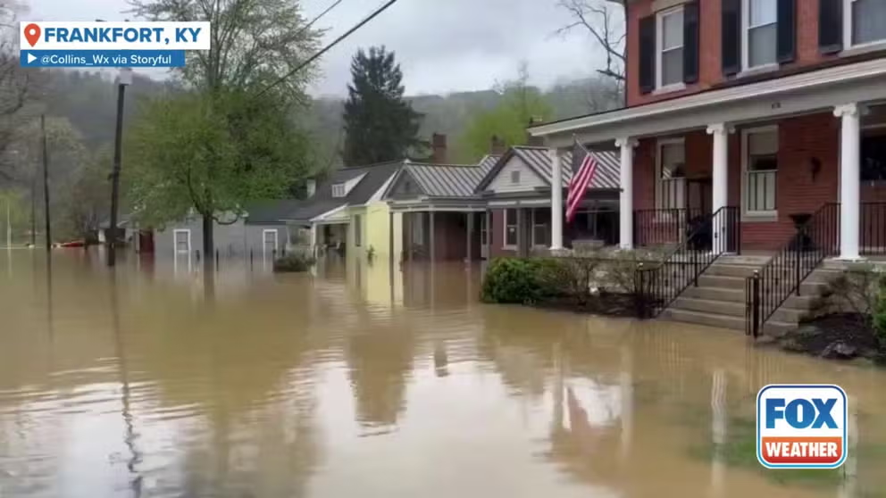
A mandatory curfew was in effect in Frankfort, Kentucky, on Sunday, as dangerous and historic flooding threatened parts of the state. Footage captured by X user @Collins_Wx shows crews from the Winchester Fire Department conducting search and rescues in a flooded street of Frankfort.
President Donald Trump approved emergency disaster declarations for Arkansas, Tennessee and Kentucky, allowing the Federal Emergency Management Agency (FEMA) to provide additional support for communities grappling with the scope of the historic disaster.
In Kentucky, the National Guard, Kentucky State Police and other state and local leaders have been working tirelessly to keep people safe and have urged residents to avoid travel if possible until all the water recedes.
At a news conference earlier this week, Kentucky Gov. Andy Beshear said that the biggest concern was people who were still trying to travel on state roads and highways. He referenced a local news story about a person who needed to be rescued after driving around a barricade.

On Sunday, as the Kentucky River in Frankfort continued to rise during extensive flooding, a video captured from the War Mothers Memorial Bridge showed a dock floating down the river, smashing into the bridge.
“When you do that, you not only put your life in danger, you put the lives of everybody who’s coming to rescue you in danger. We need people to wait this out.”
The historic flooding that has plagued communities in the Mississippi and Ohio valleys has led to mandatory evacuations in Tennessee.
Dyer County Mayor David Quick issued mandatory evacuation orders this week for Cocklebur and surrounding communities in Bogota due to the significant flooding impacts in the community.
According to Tennessee officials, damage assessments are ongoing in the state, and Joint Preliminary Damage Assessments have been completed in 10 counties.
“The results of these assessments help determine whether the damage meets the requirements, as defined by law, for a federal major disaster declaration to be requested,” officials said in an update. “A declaration is typically based on the severity and magnitude of the event, and whether the affected areas are unable to recover without external support.”
Residents are asked to take photos of damage to their homes or property before cleanup efforts and note any lossses.